Scientist calls for caution in using Turkana aquifers
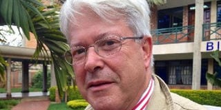
Dr Alain Gachet, the French scientist and president of Radar Technologies International, who led the search for ground water sources in Turkana. Courtesy
What you need to know:
Dr Gachet, the president of Radar Technologies International (RTI), says over-exploitation and oil drilling could lead to the depletion of the aquifers.
RTI recommended that the search for underground water systems be expanded to other areas of the country.
The firm was contracted by Unesco to conduct an advanced survey of ground water resources in northern and central areas of Turkana County.
A scientist who led the discovery of two large aquifers in Turkana County has called for caution in the drilling of water wells.
Alain Gachet, the president of Radar Technologies International (RTI), said over-exploitation could lead to the depletion of the aquifers.
“There is need to closely monitor them and ensure a balance between the reserves and the amount of water that is being recharged. It is just like your bank account — if you take out more money than you have then you will become bankrupt,” Dr Gachet told the Business Daily in an interview.
RTI was contracted by Unesco to conduct an advanced survey of ground water resources in northern and central areas of Turkana County.
The survey found deep-seated water systems with a storage potential of 250 billion cubic metres in Kachoda, Gatome, Nkalale and Lockichar areas, with the largest aquifer being located in Lokitipi.
Residents of Turkana have for years suffered drought due to lack of rainfall, and conflict between communities over limited resources.
The discovery of the resource, which can serve Kenyans for 70 years, is expected to transform the county and boost nationwide access to safe and clean water.
“The Kenyan government and other research institutions should conduct studies on a regular basis to assess the potential and the vulnerability of the new water resources. Several factors are constantly at play and monitoring the salinity and how the aquifers are affected by rainfall levels will be necessary,” said Dr Gachet.
The company’s WATEX system uses satellite imaging to accurately identify places that can be drilled for wells with the most chances of success, reducing wastage of resources.
The system was developed in 2004 and has since been used to identify water in semi-arid areas of Angola, Chad, Darfur and Afghanistan, though the Kenyan aquifers have been the largest finds.
Dr Gachet said rainfall patterns, especially in the central highlands and those in Uganda believed to feed the aquifers, should be monitored keenly.
Oil exploration companies have since last year raised expectation of commercial oil reserves in Turkana.
“Oil will naturally be found above the water and drilling could affect the water tables. Both resources are vital to transforming the livelihoods of Turkana people and joint research with oil companies could establish how one could be affected by the other,” he added
RTI recommended that the search for underground water systems be expanded to other areas of the country.
The Lokitipi aquifer is naturally replenished with about 3.4 billion cubic metres of water per year, meaning this is the amount that would be drawn each year to keep the reservoir intact.
Director of water resources John Nyaoro said Kenya presently uses three billion cubic metres per year of water, thus the recharge in the Turkana aquifer was adequate to supply the whole country, although the distance and the terrain would make this difficult.
The Lokitipi aquifer is located between Lokichogio and Lokitaung. The other aquifer is 16km from Lodwar town and is partly fed by the Turkwel River.
PAYE Tax Calculator
Note: The results are not exact but very close to the actual.