Innovator clicks on big conservation idea with app that keeps track of trees growth
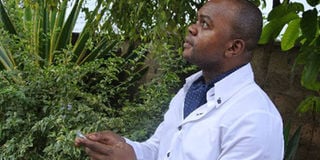
Lawi Njeremani, consultant co-ordinator of the tree planting initiative, checks the GPRS co-ordinates of a tree -planting site. PHOTO | SARAH OOKO
Forty-six-year-old Gideon Maina decided to grow trees on his one-acre piece of land in Rongai last year. Being on a slope, he says that rain surface water had massively eroded the soil hence making the land infertile.
“So my strategy was to have the trees there for a while to improve the soil quality.”
But Mr Maina works in Mombasa and lives with his family. He therefore could not get ample time to monitor the trees frequently in their initial growth stages.
“When I went back in December, I was shocked to discover that many of the trees were in bad shape and most had dried out completely,” Mr Maina told Digital Business.
He is one of the many Kenyans who despite having the desire to invest in trees, often give up along the way due to monitoring hurdles.
Kenya’s forest cover currently stands at six per cent, just slightly more than half of the United Nations recommended ratio of 10 per cent .
To bridge this gap, various global organisations have embarked on tree-planting campaigns aimed at encouraging people to grow trees in their communities.
Through its partnership with the Aga Khan Foundation, the Lions Clubs International has also embraced this initiative and is rolling it out in different parts of the country.
To tackle the monitoring hurdle, Mr Lawi Njeremani, consultant co-ordinator of the tree planting initiative drive in Kenya, notes that he began using the My GPS Co-ordinates App that can be downloaded in Android or Apple phones.
Even though its use is mostly prevalent in the transport sector where people rely on it to identify various locations, Mr Njeremani chose to creatively use it for environmental conservation.
The tool is now used by all Lions Clubs in Kenya to enable them track the progress of trees they have planted in various parts of the country.
“When we began last year, I couldn’t find a special app to help with monitoring. So I recommended that we use an already available technology and adapt it to our needs.”
Before the tree planting exercises begins, the participating Lions Club members are required to first download the My GPS co-ordinates App.
Upon reaching the planting site, they activate the application and it immediately begins picking location details (longitude and latitude) of the area.
The site’s co-ordinates together with information on the tree species planted are then forwarded to a central Lions office database through an Internet-enabled phone. When interested parties click on the co-ordinates or search them through Google Maps, they are able to see ground images of the planting site.
The initial pictures, just after the planting exercise ends, will appear greyish or brownish as a reflection of bare land. Then gradually, as the trees begin sprouting leaves, the images from the site start developing a green colour which intensifies as the plants develop further.
Mr Njeremani says that the application has enabled them to keep stock of tree planting initiatives rolled out by different Lions clubs in the country. Each time the application is used for monitoring, he urges users to take screen shots of the images to enable them make comparisons and ascertain the trees status.
“We are also able to send the co-ordinates abroad to our partners from the Aga Khan Foundation to enable them track our activities as well.”
Despite its advantages, Mr Njeremani notes that the application still has its fair share of shortcomings.
For instance, Google Maps provides long range satellite images that are not as clear and precise as pictures taken from close range. The ground images also lack sufficient information about the trees.
“You only see green or brown. And during rainy seasons both the grass and tree-covered land appear green. So it can get confusing.”
As such, Njeremani notes that more technological innovations are needed to appropriately address monitoring challenges faced by conservationists.
There are already certain breakthroughs in this area. For instance, a tool known as Data Logger is used by the Kenya Forest Research Institute (Kefri) to monitor tree seedlings. The device collects data on temperature and humidity conditions in plant nurseries thus ensuring that they grow under optimal environmental conditions at all times.
Mr Ndiang’ui Kinyagia, an information technology expert at Ari Software Company said plant monitoring applications can be developed.
He notes that various innovative ideas can be pursued to tackle the monitoring challenge.
For instance, Mr Kinyagia states that people can manually monitor the trees then use an app to feed the data and clear images to a central system that can be virtually accessed by targeted groups.
Similarly, he adds that special cameras with SIM-cards and weather recording devices can be placed in planting sites. They will then automatically send real time images of the trees complete with information on environmental conditions of the area.
“So when you notice that the temperatures are high, then you can move in quickly to water the trees before they dry up.”
He adds that the apps could also be linked to social media tools such as Instagram to encourage people to send photos of the trees they plant. “This will make tree planting look cool and encourage many youngsters to embrace it.”
Mr Maina states that having reliable plant monitoring apps would help busy farmers like him not only monitor their trees but also monitor the status of other farm crops from their offices. But for such innovations to work, heavy investment in Internet infrastructure and data storage systems is required.