Remote sensing data provides vital information on environment and aid predict disease outbreak.
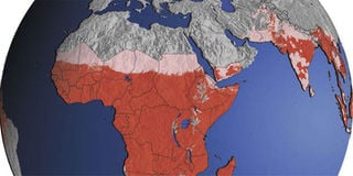
Malaria is a scourge that scientists have tried to tackle over the centuries through ever more innovative techniques. In the latest such battle, satellites are being deployed in Kenya to fight Malaria.
UK-based firm Airbus is using satellite technology to map and monitor the disease and to predict areas that are vulnerable to an outbreak.
The company uses satellite data to pinpoint areas where mosquitos are likely to breed by using a wealth of information that includes temperature, vegetation status, daily weather, urban environment parameters and other geo-climatic indicators.
“Through combination of these parameters we can map the area where mosquitoes mostly can breed, grow and eventually are a potential malaria risk,” says Fabio Domenico Vescovi, an official with Airbus.
The company is working with the government, through Kenya Medical Research Institute, to ensure the success and adoption of the application that is currently on the pilot phase in Homa Bay.
“The government uses data that has been collected from the application to make quick decision in combating breeding of mosquitoes using the information that has been made available by the satellite,” said Mr Vescovi.
The firm is now in negotiations with both the national and county governments to sell the product although Airbus declined to disclose the estimated value of the project.
This is only the latest example of how modern mapping technology can be used to address the developmental challenges that have dogged countries such as Kenya for decades.
Airbus is also working with insurance firms to provide updates on the state of vegetation and water in given regions where farmers, who have bought polices, operate.
Data collected through satellite mapping can be used to identify trigger events such as a shortage of water and vegetation. This would then help the insurance firms to plan in advance on compensation or for the government to supply fodder and water before the situation worsens.
In Nyando, satellite technology is being used to monitor water pollution through an application that shows eutrophication (excessive nutrients), phenomena that are likely to lead into abnormal flowering of floating hyacinth, which has been causing serious damages to navigation and fishery activities.
The app has the ability to show uncharacteristic increase of satellite vegetation indices on the water, which can be explained with an increase of soil, chemical fertiliser and organic matter, which is transported by the Nyando River, especially during the rainy season.
Satellite monitoring of Lake Victoria provide vital data on the status of the water body and helps in making informed decisions on the extent of pollution.
Kenya lacks developed mapping systems, which has hampered public planning, especially in natural resource management. A number of companies and State agencies have been turning to mapping technology to improve the robustness of data locally available to the government. The Regional Centre for Mapping of Resources for Development (RCMRD) is developing publicly accessible digital maps using technology developed partly by America’s National Aeronautics and Space Administration.
These maps show agricultural data such as the spread of the maize crop in western Kenya. The digital crop cover map can be accessed online on the RCMRD open data web portal. The platform also provides links to other types of land use maps from member states in eastern and southern Africa.
Scholars are also turning to unusual avenues to collect mapping data. At the Technical University of Kenya researchers are exploring the use of drones to map land ownership in Africa.
The drones would photograph the hedges that make up the boundaries of most properties from the air and maps from these photos are then linked to ownership records in the land register.
However, the project is yet to fully take off the ground as the researchers await regulatory go-ahead.
PAYE Tax Calculator
Note: The results are not exact but very close to the actual.