Time flies with great content! Renew in to keep enjoying all our premium content.
Prime
Flowering plants map a boon for beekeepers
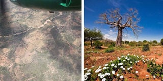
(Left) An aerial view of the mapping in process. (Right) White flowering acacia could be mapped with high accuracy: Kenya has a capacity to produce 100,000 tonnes of honey a year. PHOTOS | COURTESY
Scientists at the International Centre for Insect Physiology and Ecology (Icipe), in collaboration with other partners, have developed the world’s first-ever map of flowering plants in Africa to help understand the environmental affects the productivity of bees, their vulnerability to pests and diseases.
The map that is expected to boost bee-keeping, is based on a remote-sensing system that uses a satellite camera.
“Based on its successful testing, we now intend to upscale and adapt the methodology we have developed so that it can also be used on satellite data,” said Tobias Landmann, head of Icipe’s Geo-Information Unit.
“We expect that its wider application will contribute towards filling critical gaps, especially in Africa, on floral diversity,” he added.
The researchers use spatial distribution, abundance and temporal cycle of flowering melliferous plants (those that produce nectar and pollen, which is collected by honey bees and converted into honey) in Mwingi County, eastern Kenya.
In the test study, the scientists used sensors on an aircraft to collect data on all flowering species over an area measuring 100 square kilometres in Mwingi County, Landmann said.
The study attained overall 83 per cent mapping accuracy that was valid for producing a map “showing the distribution, abundance, season and duration of bloom of melliferous plants, otherwise known as a floral cycle.” These findings, he adds, show it is possible to use remote sensing to map flowers precisely.
The tool — hyperspectral technology— is one of the most advanced remote sensing strategies that combines digital imaging and spectroscopy to increase the ability to detect discrete materials and to gather key information for identification and classification.
In a paper published in the Remote Sensing of Environment journal, Landmann observes, most studies conducted globally on flowering species previously have used ground-based methods.
However, such approaches are not cost-effective or comprehensive, and they are also prone to errors.
Remote sensing
Remote sensing saves time, is relatively economical, and allows collection of data in areas that would be inaccessible on the ground.
He further noted that remote sensing can either be conducted via space or airborne platforms. Space platforms, however, do not always provide the appropriate data resolution.
Airborne platforms are more ideal because they operate from a much lower level than space platforms, thereby providing higher resolution data.
“Our hope is that better understanding of floral diversity will enable decision makers and beekeepers to discern the interaction between bee colonies and the floral environment, leading to optimised beekeeping,” Landmann said.
Knowledge of floral diversity is critical, as it provides understanding of how environmental factors in a given area affect the productivity of bees, or their vulnerability to pests and diseases.
As an example, a decrease in the availability of melliferous plants within a landscape, for instance due to deforestation, would indicate that beekeeping and crop pollination have been compromised.
Dr Landmann enlightens said an airborne - imaging sensor system was deployed on a light aircraft and flown over an area, 10 by 10 kilometres, in the county. At the same time flowering plants in the field were tagged in an exercise conducted twice a year since 2013.
The ground information was then related to the imagery hence the new mapping method.
Floral calendars
“Essentially the mapping method used the change in floral activity over time to separate out flowering plants from all the other features in the landscape like green trees, fields, houses and bare soil surfaces. Due to the project’s success we believe that flowering can be mapped over larger tracts of land, however, space-borne data is more recommended for its effectiveness, repetitiveness and by the fact that it can be done at a wider scale.”
Knowledge on floral cycles can also be used to draw up flowering calendars, which categorises flowers, their value to bees, abundance, season and duration of bloom.
Floral calendars help to understand bee diversity, and they also underpin landscape conservation efforts that focus on the value of flowering plants for beekeeping across the country, considering the indicative floral areas in the country are all over except the desert biomes, like northern to north-eastern Kenya.
Floral diversity
“Our hope is that better understanding of floral diversity will enable policy makers and beekeepers to discern the interaction between bee colonies and the floral environment, leading to optimised beekeeping,” says the expert.
Flowering patterns, he said, are an important indicator of a range of factors such as climate change, soil moisture, and remote sensing of floral diversity will contribute to “the ultimate goal” of enhancing food security in Africa.
On a budget of $25,000 (Sh2.6 million) project funded by the European Union would be up-scaled to produce more results for farmers and everyone else.
“The beneficiary of this technology is not just farmers. In the aspect of looking at Kenya’s landscape and its positive effects on flowering plants, bee keeping, food security and climate change, everyone needs to be aware of the pollinators and flowering plants.”
Kenya’s bee population has been falling in the past years due to pests, diseases, and the dreaded Colony Collapse Disorder.
Distribution of bees in Kenya, for instance, is found in all biomes in Kenya except in the desert. Bees can even thrive in semi-arid and arid and relatively ‘unproductive’ landscapes, however the potential to harness bee products and engage in bee keeping has not been fully exploited yet.
Dr Landmann indicates that deforestation contributes highly to the decrease of bees and hurt vegetation and compromise food security.
Kenya has potential of producing 100,000 tonnes of honey annually. However, only 20 per cent of land suitable for bee keeping is in use.
Deputy President William Ruto has said in the past that protecting bees and restoring their ideal habitats is the least Kenya can do for continued pollination.
This, according to Dr Landmann, is only possible if the floral diversity is achieved.
“Bees provide our farmers with an often unrecognised and undervalued free service, and they play a key role in the pollination of our crops and plants, including our forests.
With the global decline of pollinators, on our minds a better understanding of the local African pollinator diversity, their ecology and health status, will provide valuable insights on which we can build upon to ensure we maintain this critical service for the benefit of future generations,” Mr Ruto said.
In 2014, the African Reference Laboratory for Bee Health, was launched in Kenya at Icipe to improve the understanding of bees. More than 70 per cent of the world’s major crops rely on bee pollination to produce fruit and seeds, according to the Icipe- African Reference Laboratory for Bee Health.