Time flies with great content! Renew in to keep enjoying all our premium content.
Prime
Elgeyo Marakwet, West Pokot bank on special grass to end landslides
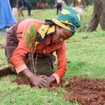
Elgeyo Marakwet Governor Alex Tolgos makes a point accompanied by county officials during a visit to Mr Samuel Teimuge’s farm in Kapsoo village. PHOTO | ONYANGO K'ONYANGO | NMG
For decades now Elgeyo Marakwet and West Pokot counties have experienced catastrophic landslides. Every year they lose tens of people and millions worth of property to these storms.
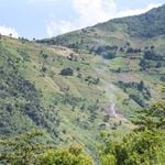
It is a precarious situation that is attributed to unbridled human activities in Kerio Valley where residents have encroached on restricted zones to cultivate, leaving the ecosystem fragile.
Over time, the ground has been left bare and whenever it rains deep gullies form leaving the land unproductive and desolate.
But the residents are starting to combat the rampant soil erosion and reclaim the gully-ridden escarpment using a most ingenious solution-vetiver, a type of grass.
Vetiver has a deep root system that holds the soil firmly together. Unlike other grass whose roots spread loosely horizontally, its roots grow downward to a depth of two to four metres. It grows up to 1.5 metres high and can withstand flooding as it slows the surface runoff water.
It also has an expansive pattern and grows in bunches with its leaves expanding up to 150cm growing from the underground crown making the grass fire-resistant and enduring heavy grazing and droughts.
Mr Samuel Teimuge’s farm, in Kapsoo village-Elgeyo Marakwet, has become a model after he established vetiver grass. The landscape is changing from gulleys into grass bushes and the once bare ground is now productive.
“Before nobody would dare venture into my farm for fear of falling into the deep gulleys. In fact, I lost several of my animals to the gulleys, but when I planted vetiver, the gradient on my farm is now gentle with the gulleys steadily filling up,” said Mr Teimuge.
He said the root system spreads and penetrates soft rock and is finely structured compacting the soil against any form of erosion.
“The grass also acts as animal feed when the leaves are still tender and I am pleased the gulleys, which had been a nightmare are gradually being filled up,” added.
When the grass was introduced to them at Cheptebo rural development centre following a series of sensitisation forums on land reclamation, Mr Teimuge, at first skeptical, figured he had nothing to lose by giving it a try. After all, he reasoned, nothing else had worked thus far.
Today he is among the most devouted evangelists of the vetiver soil reclamation gospel. "I urge residents to grow vetiver to help mitigate soil erosion and bring to an end the frequent landslides," he said.
And his gospel has found receptive ears with other residents planting the grass after seeing the extraordinary transformation of Me Teimuge’s land.
Mr Peter Komen said: “The grass is very strong and it withstands heavy downpours. Since we adopted growing this grass we have witnessed deep gulleys steadily being filled up.”
Mr Komen and Mr Teimuge said besides planting the grass, residents should also heed the directives of government officers to ensure that their practices to do not contribute to further environmental degradation, he urged.
According to the National Environment Management Authority Integrated National Land Use guidelines, there should be no cultivation at all on slopes beyond 55 percent gradient (slope). It instead advises that such areas should be planted with trees and protection offered to exist vegetation.
Cognisant of the dangers of cultivating on the escarpment, the colonial government had come up with a boundary, referred by the locals as the ‘Spencer Line’ beyond which no activity should take place.
‘Spencer Line’ was coined after colonial administrator William Spencer who demarcated the boundary on the escarpment.
But today Elgeyo Marakwet’s county disaster department indicates that over 50,000 households live on the escarpment with 4,000 families inhabiting high-risk zones.
At Sangat village in West Pokot Mr Solomon Adongonyang who has adopted the growing vetiver grass said it was proving to be a lasting solution.
“Initially an Italian firm had constructed gabions by using cement which was washed away by floods, but vetiver grass has adaptive characteristics that make it hard to be easily washed away,” he said.
Mr Adongonyang, a member of a community-based organisation in the area, said that the residents are receptive to the new intervention and have embraced planting the grass.
He added that environmental protection was everyone’s responsibility, noting that because people living on the highlands had destroyed the environment, those on the lowland also paid the price when mudslides came.
Elgeyo Marakwet governor Alex Tolgos said with the initiative, landslides could soon be a thing of the past, enabling residents to participate fully in the development of the region.
“The use of vetiver has indeed proved to effectively combat soil erosion that is synonymous with the escarpments. We are encouraging locals to emulate those who have planted vetiver grass to mitigate the effects of mudslide and erosion on their farms,” appealed Mr Tolgos.
Farming practices
The governor said a huge chunk of Rift Valley escarpment traversing Nandi, Samburu, Baringo, Elgeyo Marakwet, West Pokot, Trans Nzoia, Bungoma and Turkana counties is prone to landslides but unfortunately the environment on these precarious areas has been wantonly destroyed.
“Poor farming practices have worsened soil erosion making deep gulleys in times of heavy rains, resulting in mudslides. The majority of these counties are hilly and the residents do not practice safe farming like terracing and with the vetiver grass, this issue could be mitigated to act as a lasting solution,” he said.
Mr Tolgos, however, said the region has huge agricultural potential because of favourable climatic conditions for Agriculture but soil erosion was a threat.
Environment Principal Secretary (PS) Dr Chris Kiptoo rued the degradation of the escarpment cutting across the two counties revealing they have put in place an integrated master plan for the rehabilitation and restoration of the Elgeyo-Cherang’any hills ecosystem which covers the two landslide-prone counties and forms part of the five country’s water towers.
According to Dr Kiptoo, the country should plant seven million trees by the end of this year and another eight million by the end of 2022 for the sake of achieving the 10 percent forest cover objective.
"2030 was set as the year that our country was to achieve 10 percent forest cover but our President revised it to 2022. Therefore, we plan to plant 7 million trees next year and another 8 million in 2022," said the PS at a past function in Kaptagat forest.
He also revealed that the government has already approved the expansion of the Kenya Forestry Research Institute (KEFRI) from the current six centres to 16 as part of efforts to attain the required minimum tree cover.
“Through expansion we want KEFRI to train more staff and provide the necessary expertise that will enable us to implement the strategy we have,” he said.
Dr Kiptoo said the state is working with all counties in the plan to plant more trees. Each has been given a target of planting more than 43 million trees as part of the collective efforts to get to 10 percent tree cover.
According to the 2018 report on Land Degradation Assessment in Kenya, soil erosion risk mapping revealed that almost all the counties are at risk from one form of land degradation or another.
The problem is serious because high land degradation is likely to occur in about 61.4 percent of the total area of Kenya, while very high degradation affects 27.2 percent of the land.
The report says that land degradation affects especially the arid and semi-arid lands (ASALs), where the soils are highly erodible and combined with high-intensity storms, creating conditions for excessive runoff and soil erosion.
The most affected counties include Samburu, Kitui, Garissa, Tana River, Mandera, Turkana, Marsabit, Baringo, West Pokot, Kajiado, Kilifi, Wajir and Makueni.
“Even some relatively wetter zones also have a high propensity for soil erosion, especially on steep slopes of Mt. Kenya and the Aberdares, including parts of Muranga, Nyeri, Meru and Tharaka-Nithi. On the contrary, low degradation risks were found to be on protected areas and those with relatively flat terrains yet having adequate rainfall.
These include the forest zones, national parks, tea-growing areas and plateaus such as Uasin Gishu, Trans Nzoia and parts of Lake Victoria basin,” explained the report.
It added that: “Meanwhile, the causes of land degradation in Kenya are both natural and human-induced. They include biophysical (natural) factors related to climatic conditions and extreme weather events such as droughts and floods and catchment factors such as steep slopes and highly erodible soils.
However, it is the human activities that pose the greatest threat, and these include unsustainable lands management practices (anthropogenic) factors such as destruction of natural vegetation, over-cultivation, overgrazing, poor land husbandry and excessive forest conversion.”