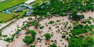
Losing residence owing to calamities such as floods must be devastating. It comes with threats to life, loss of property, disruption of earnings and loss of a social ecosystem. The associated emotional and sentimental loss is beyond imagination.
Their plight should be addressed sufficiently, and quickly, and not be used as fodder for ping-pong politics. But Kenya must learn lessons. While the occurrence of natural disasters, and the prevailing climate change consequences may be beyond us, we are endowed with skills and capacity to innovate and mitigate accordingly.
Reason why last week’s statement by the Institution of Surveyors of Kenya (ISK) on the ongoing floods adds good value. ISK noted that the flooding may have been aggravated by the clearing of riparian reserves, disregard for planning and zoning regulations, uncontrolled development and blocking of water ways, among others. The Institute cautioned about the likelihood of severer floods in future.
ISK proposed a raft of mitigation measures. These include the declaration of storm waterways to be public land and the control of land use on riparian reserves. It proposes the use of geospatial techniques such as aerial surveys and mapping to undertake urgent baseline surveys of the affected areas during and after the flooding.
The collected data will guide post-flooding analysis and the formulation of plans to mitigate the consequences of recurrence. Satellite data may be collected to monitor stormwater flow or changes in water levels in water bodies, and used for early warning and evacuation plans.
Topographical surveys should precede site construction. The ISK advisory note would be quite helpful to policy planners in government and the private sector.
Some context will help. Geospatial measurements, the forte of land surveyors, also referred to as geospatial experts, help to provide information on the relative positions, including heights of objects or phenomena on the surface of the earth.
Where adequate and appropriate, such information would help to profile surface water flow, and therefore help to identify buildings, or other fixtures, that may obstruct drainage or flood water.
It could further serve as the basis for the rejection of development applications that breach stipulated development levels along ocean, lake and river reserves. Such data is invaluable to national and county governments.
Where integrated with data from current and historical aerial imagery on floods, it could be modelled to flag out flood-prone basins and belts. Property buyers would also be able to use such information to avoid “plots on sale” in unsuitable zones.
To obtain such data, the government will need to support the national surveying and mapping agency under the Director of Surveys to produce appropriate topographical and topo-cadastral maps, at appropriate scales.
Such base maps should inform all county spatial and development plans. In addition, approvals to building plans should be buttressed by site-specific topographical surveys to guide decisions on the positions and directions of surface water run-off infrastructure.