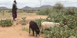
Atop a hilly terrainsituated in Laikipia County, pastoralists roam around with livestock – (mainly sheep, goats and cows) in search of pasture.
The vast land used for grazing by the community is largely bare, eroded and severely degraded.
A bird’s eye view of the ground reveals light-brown soils with tiny patches of vegetation and thickets stretching into the horizon.
The sun is high up the sky, its scorching rays harsh on the skin. But the pastoralists soldier on, dedicated to the wellbeing of livestock that are their main source of livelihood.
Every once in a while, the wind blowing through the land offers them reprieve from the heat—albeit momentarily – even as it blows away the loose soils, causing further land degradation.
Rainfall pounded the area a few days before our visit, causing grass to spring up in some parts of the land. It is however insufficient.
Livestock are thus forced to complement it with a type of cactus plant known as opuntia that appears to be the only vegetation thriving in the area.
But the invasive plant leaves a sour taste in the mouth of Makurian pastoralists who describe it as the “devil cactus” due to its devastating effects on livestock health and pasture availability.
The fruits and leaves of opuntia contain spines that cause painful ulcers or wounds in the mouth and intestines of livestock. They may also pierce eyes as animals feed on them, thus leading to blindness. Worse still, the seeds in the fruit can block stomachs of livestock hence resulting in death.
In an attempt to dull the unbearable pain, especially after the wounds “eat-up” their lips, affected animals usually stay with their mouthS open and teeth hanging out.
“An outsider might think that they are smiling when they are actually dying of pain which makes it impossible for them to feed. So you just have to kill the animal,” says Wilfred ole Mejooli, an affected pastoralist in Makurian.
“Yet opuntia can’t go away. It has colonised our grazing land, preventing grass and other vegetation that serve as good livestock pasture from growing,” states Mejooli, as he goes about herding livestock and taking photos of the plant using his smart phone camera.
He stops briefly and lifts his grazing stick to point at abandoned homesteads across the land.
“It’s not just the cattle. Most of our relatives have deserted the area because they can’t stand the plant. Maasais are communal. So it really hurts when we’re disconnected.”
Animals feed on opuntia at Makurian. PHOTO | SARAH OOKO
As opuntia continues to ravage the land, he notes that it is becoming harder and harder to fend for his wife and five children.
“With no grass, the animals don’t produce enough milk and meat. So their value is useless in the market. Before opuntia, a good looking cow could go for Sh50,000. But it is now half the price as animals look like baskets of bones.”
“We are all scared that if we don’t get a solution to this problem, this opuntia will destroy our only source of livelihood and finish us completely.”
But before that happens, Mejooli is going after the enemy plant with a technological weapon that he hopes will generate solutions to the challenge and come to their rescue.
In his smartphone, he has downloaded an app known as the Invasive Species Mapper that was developed by SERVIR in collaboration with the regional centre for mapping resources for development (RCMRD).
Every day, as pastoralists like him walk for miles herding livestock, they use the app to take photos of opuntia whenever they come across the plant. They indicate locations of areas infested with opuntia by capturing their Global Positioning System (GPS) co-ordinates, even as they estimate the amount of land covered by the plant.
The information goes to a central server at RCMRD where scientists combine it with climatic data from America’s National Aeronautics and Space Administration (NASA) satellites.
These aggregated data sets are then used to generate high resolution maps that depict areas covered by the plant in northern Kenya.
“The maps provide information on where the plant currently is and where it is likely to move to in about 50 or 60 years to come,” said Edward Ouko, a geographic information system (GIS) expert and head of the invasive species mapping initiative by RCMRD and SERVIR.
Aside from opuntia, the app is also used to map another type of invasive acacia tree (known scientifically as acacia reficiens) that is wreaking havoc on pastoralists in parts of Samburu, Isiolo and Marsabit counties.
Just like Opuntia, these trees multiply rapidly in degraded lands and proceed to displace other types of vegetation present in areas where they thrive.
Experts worry that if left uncontrolled, the spread of these invasive species will continue to dent economies of counties in arid and semi-arid areas (ASALs) where over 70 per cent of Kenya’s livestock and wildlife are found. Such challenges have contributed immensely to declines in livestock production income in the country.
Indeed, the 2018 Kenya Economic survey shows that the sector’s contribution to the country’s gross domestic product (GDP) was 4.4 per cent in 2017, down from 5.3percent in 2013.
Once completed, Mr Ouko noted that the opuntia and acacia maps are then sent back to pastoralists, public institutions and non-governmental organisations (such as the Laikipia Wildlife Forum and Northern Range Land Trust) that are supporting affected communities to eradicate the invasive plants.
Mr Ouko stated that the maps are also “open-access” and can thus be retrieved by the public at no cost from the RCMRD website.
“This is aimed at encouraging as many people as possible to devise innovative ways or approaches that can complement existing strategies used to fight the invasive plants.”
John Letai, deputy director of environment and natural resources in Laikipia County said that for a long time, the county relied on “hearsay” to determine areas affected by the plants in the region.
“This approach is prone to errors. And that’s why we’ve decided to embrace mapping so we can get reliable information on the coverage of opuntia.”
He added: “This makes it possible to channel opuntia elimination efforts and the available scarce resources to where they are needed the most.”
Laikipia county which is worst hit by opuntia requires about Sh200 million to eradicate opuntia. But the county is still unable to raise these funds.
“Mapping provides evidence and this will help us with resource mobilisation initiatives.”
Peter Hertz, chief executive officer (CEO) of the Laikipia Wildlife Forum (LWF) noted that the maps are effective tools for assessing impact of eradication strategies. “The maps produced so far, provide us with baseline data on where the invasive plants currently are. We can therefore do a before and after assessment to gauge progress made in eradicating them.”
According to Hertz, maps should not be an end to themselves.
“Mapping is great. But once it shows us the extent of the problem, we have to act. Otherwise, such technological innovations will serve no purpose.”
To control and curtail the spread of the invasive species, communities in affected areas are advised to manually remove or uproot the plants.
This approach works best for acacia. But it is often unsuccessful for opuntia control as the plant is able to completely regrow if the smallest bit of root is left in the soil.
Scientists have thus introduced an alternative biological control method that involves the use of certain bacteria which feed on the opuntia plant and destroy it completely hence preventing it from multiplying and spreading further.
“These are costly interventions and that’s why we need the maps to guide our decision making process so we can use the little resources we have efficiently and achieve maximum impact,” said Tom Lalampaa, CEO of the Northern Rangelands Trust (NRT).
Once the invasive plants are eradicated, he noted that the degraded lands need to be rehabilitated so they can become suitable grazing lands with adequate pasture (grass and other valuable vegetation) for enhanced livestock production.
“In severely degraded lands, we usually have to start afresh by replanting grass and other valuable plants that existed before the invasive species came.”
According to Mejooli, the involvement of pastoralists in the mapping project has enabled communities to understand the link between poor livestock practises that degrade land (like overgrazing) and the spread of the detrimental invasive plants. “This has helped them to become more receptive to change and supportive of strategies like rotational grazing that prevent land degradation.”
Mr Ouko said technological skills acquired through the use of the app are also helping to bridge the prevailing huge digital gap between urban and rural communities in Kenya.