Time flies with great content! Renew in to keep enjoying all our premium content.
Prime
From Lamu, a spatial plan lesson for counties
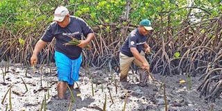
Planting mangroves in Lamu: It’s unfortunate that most development plans have ruined natural assets. FILE PHOTO | NMG
Lamu County is stepping into a new era of large-scale development and infrastructure investment, particularly through the multi-million dollar Lamu Port, South Sudan and Ethiopia Transport (Lapsset) Corridor project. While these developments could generate substantial economic and social benefits, they also pose significant risks.
In particular, if poorly executed, they could lead to significant and, in some cases, irreversible damage to the county’s most important natural assets, including forests, grasslands, mangroves, water sources, beaches, seagrass beds, coral reefs and fishing areas.
Many of Lamu’s natural assets are on a steep downward trend due to human pressures. Mangroves and terrestrial forests are declining rapidly, in terms of both quantity and condition.
Kenya has already lost almost 40 per cent of its mangroves in the last 30 years, mostly from Lamu County (which hosts some 70 per cent of Kenya’s total mangrove stock). Water sources such as rivers and aquifers; and marine fish stocks are also being rapidly depleted and degraded.
Among the greatest threats affecting Lamu’s natural assets are the clearance of habitats, for instance as a result of the Lapsset.
Other threats include conversion of forests into farmlands and increased abstraction of natural resources (like water, timber and fish) by the growing population.
The Lapsset authority is in the right direction in ensuring that all these adverse effects are mitigated through the Strategic Environment Impact assessments and ensuring that the corridor is undertaken through a green environment.
On a social perspective, the authority is also undertaking assessments on how to compensate the fisher folk on lost livelihoods. Implementation of the project with these environmental and social safeguards in place will ensure an investment which benefits the immediate community and the nation.
The County Government Act 2012 stipulates that all counties should prepare county spatial plans to guide development in a period of 10 years. Preparation of the plans should be guided by the constitutional principles and should be the basis for budgetary allocation.
The plan should clearly delineate urban edges and secure critical biodiversity areas.
Lamu is the first county that has developed and approved a county spatial plan currently in the implementation phase.
The plan has taken into consideration the natural resources in Lamu and ways in which the plan will ensure that these natural assets are secured in an effective manner.
World Wide Fund for Nature (WWF)-Kenya, has been supporting four counties (Lamu, Bomet, Narok and Kwale) in the preparation of the county spatial plans.
To meet the spatial plan objective of indicating areas for conservation, WWF-Kenya has supported identifying and mapping out of these critical biodiversity areas through a participatory process.
This included engaging the communities who live around these areas, government agencies and non-governmental organisations on natural resource management as well as conducting natural capital assessment to ascertain the benefits from natural assets, key threats facing these natural assets and recommendations on how to address these threats through spatial planning.
Implementation of the Lamu spatial plan will go a long way not only in guiding development, socio-economic growth but also in securing critical biodiversity areas.
There is, however, a need to ensure that all policies and plans being developed have a robust monitoring and evaluation indicators so that Kenyans do not end up having good plans that are not adequately implemented to tap into as it has been in previous cases.
Nathan Mutunga,spatial planning officer at WWF Kenya
Unlock a world of exclusive content today!Unlock a world of exclusive content today!