Time flies with great content! Renew in to keep enjoying all our premium content.
Prime
How radar satellites can help map floods in Kenya
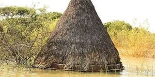
A hut at Roberts Camp Hotel submerged in Lake Baringo. FILE PHOTO | NMG
Radar science that was originally used in defence industry now has several applications in civilian and commercial realms.
Kenya can tap the technology to help mitigate problems such as floods.
The country experiences seasonal floods in certain regions such as Budalangi, Kano Plains and several parts of North Eastern and Coastal counties.
Currently, lakes Baringo, Nakuru and other Rift Valley water bodies have breached their shores, destroying property worth billions and lives.
Several multi-billion tourist hotels, lodges and tented camps are among business establishments that have been hit hard by the swelling Lake Baringo waters.
The businesses that were already reeling under the weight of the Covid-19 pandemic, have now been submerged triggering economic losses worth millions of shillings.
Radar satellite data provides an intelligent way of studying flood patterns and forming science-based decisions. Unlike other sources, petabytes of high-resolution radar data exist from missions like European Space Agency’s Sentinel satellites free.
Governments, researchers, students and investors can use the data to create early flood-warning systems.
Anybody who has interacted with young people are familiar with the slang “rada”. It loosely translates plans or status update.
Just like its use in street lingo, radar has always been associated with advanced or warning functions.
The United Kingdom Royal Air Force (RAF) used it during World War II to warn and prepare troops of impending danger.
Having witnessed the havoc that the German military had caused in Spain and neighbouring European countries, the UK embarked on a search for an early warning system.
The answer was on what is now famously known as the “Chain Home System”, which were a series of about 354-foot towers that could detect the oncoming German planes before reaching any British Coast.
Radar is a technology that emerged by mimicking biology. Just like birds influenced development of planes, crabs inspired military tanks and fish influenced submarine, radar mimicked bat.
Bats do not have eyes for sight but instead use reflected sound (echo) to detect objects. The same is the basic principle of radar, except that radio waves are used instead of sound.
Whenever there is a threat of floods, especially during heavy rains, radar technology can be used to quantify the extent of water and location of safe areas.
There exist several radar satellites. The satellites are usually located a hundred of kilometers above earth and continuously send radio waves to the ground and measure the backscattered signal.
During flooding, the surface of water bodies is relatively uniform; hence, the incident radio wave from the satellite will be reflected to a different direction that cannot be picked by the satellite. The flooded areas appears dark to the radar.
This is not the case with surrounding features such as grass, trees, buildings and other artificial objects. Due to non-uniformity in their surface, some of the incident wave will be reflected and the backscatter unrecorded by the satellite. They will appear bright.
By processing the backscattered signals recorded by the satellite to images, the flooded areas can be identified. Since a single satellite image can cover an area larger than the size of Narok County, detecting flooded areas over such a region is possible from a single image.
Once analysed, the images can give an in-depth understanding of the extent of damage and reveal safer grounds where affected population can move.
Bonface Osoro is a postgraduate student at University of Strathclyde, United Kingdom with keen interest on Low Earth Orbit (LEO) communication, radar and navigation satellites
Unlock a world of exclusive content today!Unlock a world of exclusive content today!