Time flies with great content! Renew in to keep enjoying all our premium content.
Prime
Varsities map out key Nairobi routes to ease public transport
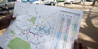
A pedestrian reads a map showing public transport routes in Nairobi after the launch of the Digital Matatus on Tuesday. Photo/Evans Habil
First-time visitors to Kenya’s capital will now find it easier to travel in and out of the city following the mapping of Nairobi’s public transit system.
The first ever map of routes for all public service vehicle is a collaborative research effort by the University of Nairobi (UoN), Columbia University, Massachusetts Institute of Technology and Groupshot to come up with an open source data for the transit system.
Speaking during the launch of the map, Prof Peter Waiganjo, a lecturer at UoN, said that the map would provide stakeholders the necessary data to help them reduce traffic congestion in the city.
“The system as it is, is fairly difficult to navigate and data is not easily accessible. While the numbering system has remained from the 80s when Kenya Bus Service used to provide public transport many of the routes have been modified and become a bit confusing,” he said
During the project a group of University of Nairobi students, equipped with mobile phones and Global Positioning System (GPS) technology, travelled through all the routes within the city mapping out the designated and undesignated stops complete with well built bus stops.
Geographic Information System was later used to develop the transit map using the data that had been collected. The map indicates routes from towns within Nairobi metropolis like Ruiru, Ngong, Ruai, Kiambu and Athi River along with route numbers allowing for visitors to sample accommodation beyond the city hotels.
It also provides a platform for transport stakeholders to improve on data collection and acquire information on how to better manage the public service vehicles.
“Looking forward we want to take the public transit system where other big cities are to create a system complete with the matatu schedules and time zones of how long it would take to travel from the central business district to other metropolitan areas,” said Prof Waiganjo.
The map, also known as Digital Matatus comes in the wake of other innovations that have sprung up to help city residents move with ease like Ma3route and Sonar.
The soft copy version of the map is available for download on www.digitalmatatus.com.
Unlock a world of exclusive content today!Unlock a world of exclusive content today!