Time flies with great content! Renew in to keep enjoying all our premium content.
Prime
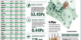
How the counties fare on forest cover as Kenya strives for elusive target
PHOTO | BD GRAPHIC
Counties in the Lake Victoria basin have some of the lowest forest covers nationally, signalling the strain on the region’s ecosystem.
Forested catchments are key for the supply of a large proportions of water for domestic and agricultural use. Isiolo has the highest forest cover with more than half of the county covered by trees while Kisumu has the least cover.
Statistics from the Kenya Open Data portal shows that Isiolo has 1.35 million hectares of forest cover against its total land mass of 2.5 million hectares which translates to 53.45 per cent.
The lakeside county of Kisumu on the other hand has 1,184 hectares of forest cover, which is 0.44 per cent of its total land mass of 267,000ha. Mombasa, Siaya, Busia, Migori, Kisii and Vihiga follow Kisumu in that order as the least forested despite receiving substantial amounts of rain.
The data highlights the strain of heavy settlements and agricultural activities on tree cover as the country struggles to attain the set target of 10 per cent forest cover.
“The current forest cover of 6.99 per cent of the land area of the country is still below the constitutional requirement of 10 per cent,” the 2015 National Forest Policy says.
Kenya has a wide array of forest ecosystems ranging from mountain rainforests, savannah woodlands, and coastal forests and mangroves. Nyeri is the second most forested county after Isiolo with 38 per cent of its total land mass under continuous tree canopy.
Other counties around Mt Kenya area also have a high forest cover with Kirinyaga at 20.6 per cent, Nyandarua (18.44 per cent) and Meru (18.3 per cent).
The Rift Valley highlands also have a high tree cover with Elgeyo Marakwet having a forest cover of 37.4 per cent, Nandi (26.2 per cent) and Baringo (25.1 per cent). The arid counties of Garissa, Mandera and Wajir have a higher forest cover than other well-watered areas. Nairobi, the capital city, has a forest cover of 7.78 per cent.
Forestry was devolved under the 2010 Constitution putting the responsibility of increasing forest cover under the 47 devolved units. Forests play critical ecological, social, cultural, and economic functions.
“They contribute directly and indirectly to the national and local economies through revenue generation and wealth creation, and it is estimated that forestry contributes to 3.6 per cent of Kenya’s GDP, excluding charcoal and direct subsistence uses,” the policy says.
“Biomass comprises about 80 per cent of all energy used in the country, while they also provide a variety of goods, which support subsistence livelihoods of many communities.”
Kenya’s major forests like Mau, Arabuko Sokoke, Mt Kenya, Karura, Kakamega and Kerio Valley have all been reported in recent years to be under threat from illegal loggers in what contributes to the diminishing of cover.
Deforestation
Decimation of forests by illegal loggers, squatter farmers and developers also endangers plant and animal species found in these areas. Deforestation in Kenya is estimated at 50,000 hectares annually, with a consequent yearly loss to the economy of over Sh1.9 billion.
Forests like Mau Complex and Mt Kenya are particularly key as natural water towers and regulate the amount of rain that falls in the outlying areas and agricultural activity by extension. “Forests comprise the country’s water towers and catchments, where over 75 per cent of the country’s renewable surface water originate, and therefore serve critical water regulation roles which are important for human livelihoods, irrigated agriculture, and production of hydro-electric power,” the policy adds.
“The forestry services provided by the water towers include local climate regulation, water regulation, water purification and waste treatment and water pollution sinks.”
In June this year, it was reported that
Arabuko Sokoke forest in Kilifi County is facing destruction by the residents living around it due to famine. The forest covers 420 square kilometres and has over 600 tree species.
The Mau forest decimation and settlement saw thousands of hectares of tree cover cut for wood, charcoal and agriculture in the 90s. The restoration of the water tower is ongoing. Conservationists have warned that continued destruction threatens the lives of numerous Rift valley lakes and the Mara River— the lifeblood of the Maasai Mara Game Reserve that is one of Kenya’s premier tourist attractions.
In February this year, reported attempts to hive of a piece of Karura forest in Nairobi by a developer were rebuffed after spirited opposition by city residents. Various reports have also indicated that Kakmega Forest- the only tropical rainforest in Kenya- is facing extinction due to deforestation by the neighbouring community and illegal loggers.
The Kenya Wildlife Service (KWS) will build a 40-kilometre fence around Marsabit Forest to check destruction of the woodland and reduce human-wildlife conflicts. Marsabit Forest is estimated to currently occupy 11,000 hectare (ha) down from over 18,000ha in 1973. The rate of forest degradation is estimated to be 180ha per annum. [email protected]
Unlock a world of exclusive content today!Unlock a world of exclusive content today!