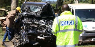
Players in the transport sector have started mapping out black spot areas along the Northern Corridor in a bid to end road carnage.
Ten “priority black spots” were identified in the five-day exercise conducted by the Northern Corridor Transit and Transport Co-ordination Authority (NCTTCA), Kenya National Highways Authority (KeNHA), National Transport and Safety Authority (NTSA), Kenya Transporters Association (KTA) and the Traffic Police Department.
The exercise began along the Northern Corridor routes from Mombasa on March 4 and ended in Kisumu on March 9, 2019, covering a total of 845 kilometres.
The 2015 Global Road Safety Status Report by the World Health Organisation shows that Kenyan roads are amongst the most dangerous in the world, claiming an average of 29.1 lives per 100,000 people.
The report also revealed that road crashes are among the top ten killers and account for between 45 and 60 percent of all admissions to surgical wards that cost the country up to 5 percent of GDP.
NCTTCA said the key objective for the exercise was to “confirm the existence of priority black spots and come up with a major injury and fatalities based black spot analysis”.
The project was also meant to prepare guidelines on black spots management along the Northern Corridor route in Kenya and help in funds mobilisation in order to address safety concerns at the black spots.
NCTTCA executive secretary Omae Nyarandi told Shipping & Logistics that the aim of the survey was to identify, diagnose and address issues that cause accidents, leading to lose of lives along the corridor.
“The exercise was an implementation of the Northern Corridor Executive Committee’s directive on improvement of safety in all transport modes and facilitation of safer transport across the member States,” Mr Nyarandi said.
“The Permanent Secretariat of NCTTCA) therefore brought together key major road safety stakeholders in Kenya to carry out a joint survey of ten priority black spots along the Northern Corridor routes in Kenya.”
Three of the black spots were indentied in Coast. These are Kibarani- Makupa Causeway, Bonje and Maji Ya Chumvi.
Others are Emali-Pipeline, Ngokomi-Kalimbini and Konza-Malili in the eastern region while two black spots were assessed at Mlolongo and Gitaru-Rungiri in Nairobi.
In Rift Valley, the team surveyed one black spot at Mukinya-Migaa-Sobea-Salgaa-Sachangwan. It then concluded with the last black spot in Kisumu that is between Molem-Nambaokana-Nyamasaria-Kasagam.
Mr Nyarandi said the commissioned survey was phase one of a broad programme of enforcing effective road user behaviour, road system design and traffic management.
“The programme will contribute to the 4th East Africa Community (EAC) Development Strategy that aims at harmonising with the African road safety performance target which is to reduce the road-related fatalities by 50 percent by 2020,” said Mr Nyarandi.
In an interview, KeNHA deputy director in charge of highway safety and training Monica Anyango said the survey conducted this month was a continuity of another mapping exercise done in 2017.
“There is a joint study that was done in 2017 with NTSA, Kura and KeNHA where they went through the entire corridor beginning from Mombasa to Malaba and then went to as far as Mau summit,” said Ms Anyango.
“What they did during that exercise was to map out those black spots or hazardous spots.”
One of the indicative measures they used, she said was the number of accidents that had happened in those spots.
“The team went round looking at the road, accident data and then came up with a brief on what could be the reason these accidents happen,” she said.
“...there are issue to do with the road, driver behaviours and condition of the vehicles among many reasons including the behaviours of the people around the road.”
KeNHA, she added carried out a detailed study in 2017, looking at some of the black spot that had already been identified. The survey relied heavily on police data reports for a period of four to five years.
“The accident data from police was analysed to assist the organisation from identifying what could be the reason why these accidents have been happening,” she said.
“When an accident happens, police usually fill in the p-41 form which gives a lot of details about the accidents. Some the details provide crucial leads to the possible causes.”
The KeNHA official said 30 blacks pots were ranked in their report.
“When this study was being done, mitigation measures to address those accidents were also listed,” she said.
“Our focus is in the NCTTCA member states. We began in Kenya but we shall then go to Uganda, Rwanda, Burundi and the DRC.”
According to NTSA data, 9,030 people had lost their lives on the Northern Corridor road network in Kenya in the last three years — 2016 (2,965), 2017 (2,919) and 2018 (3,146). Pedestrians were found to be the most prone to road carnage with 1,201 dying last year.
The NTSA data revealed that 8,272 people were injured in 2018, an increase from 6,789 in 2017.
Creating awareness
In January 2019, road accidents have claimed more lives of Kenyans than in the festive month of December 2018. This could be attributed to a scenario that may easily be attributed to the relaxed mood in creating awareness on road safety during January.
A survey released by NTSA on 25 January this year shows that 184 people have lost their lives on the roads since the year began.
The cause of the accidents are varied with 92 per cent of them being attributed to human error, with mechanical problems accounting for five per cent, while environmental issues are blamed for three per cent of the occurrences.
Mr Nyarandi said road crash statistics show that, on average, 3,000 lives are lost annually and thousands more are injured.
“This sad state of affairs can be avoided if the root causes of road traffic crashes are addressed. Road safety has become a major challenge for our corridor albeit tremendous efforts made in the development and improvement of transport infrastructure within the Northern Corridor,” he added.
The NTSA survey found speeding as the leading cause of accidents along the highway, followed by unsafe junctions and obstruction by trucks and PSV parking by road side.
Other factors included vendors selling their wares by the roadside, encroachment on road reserve, lack of designated pedestrian crossing points and non-motorised transport (NMT) facilities. Other causes were missing or non-existent of road signs and existence of numerous accesses and illegal turnings to business establishments.
Unlock a world of exclusive content today!Unlock a world of exclusive content today!