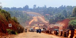
The Nairobi Western Bypass is estimated to be above 70 percent. It connects the Southern Bypass at Gitaru and the Northern Bypass at Ruaka, thereby completing the fourth and final ring road in the Nairobi Ring Road Network Masterplan which also comprises the Eastern Bypass.
It is, therefore, such an important link and will play a key role in easing the traffic menace around Nairobi. However, as the implementation advances, residents along the route are feeling short-changed, neglected and ignored and are not convinced that the project has their best interests at heart.
In our minds, the project was supposed to open the area economically. It is widely recognised that improved roads have a positive impact on rural inhabitants.
Such improvements are expected to enhance their ability to access social services, markets and jobs, and, therefore, contribute to improving their living standards. Good infrastructure also lowers the cost of doing business with reduced transport costs thus raising total factor productivity.
More specifically, other studies have indicated that for every Sh1 billion spent on road infrastructure by the government, GDP growth increases by 4.5 percent, holding other factors constant.
For the Western Bypass, however, these attendant infrastructural gains seem too close, yet too far and our high hopes and dreams attached to the project are progressively being shattered as its implementation rolls out at cheetah’s speed.
Take the area around Kirangari/Gikuni/Kibiku/Gathiga for example. In this area, basic provisions for exits and entry into the Western Bypass have completely been ignored requiring residents to drive an extra four kilometres up to Karura to access their homes.
In addition, at the Gikuni junction, a bridge that is ostensibly supposed to link the agriculture-rich region with the bypass ends abruptly at a place called Kwa Michael with no clear connection to the bypass.
Combined, Kirangari and Gathiga Locations have a population of about 65,000 people living on both sides of the road. The population is served by 17 public and private educational institutions, including primary and secondary schools and a polytechnic as well as three children’s homes.
The area is further served by 21 churches, one police station and three AP posts. In addition, the area has five manufacturing concerns. There are also several public health institutions, including the Nyathuna Level 4 Hospital.
All these businesses now hang by a thread if the current design is maintained.
This confusion would have been avoided if the implementers had only taken community participation and engagement more seriously.
However, from the look of things, this was not one of their priorities, and even if it were, all the concerns raised have been given a hefty shove out of the window.
Surprisingly, the original designs had all these issues addressed. Now, the general direction being to go, go, go without a pause for informed reflection. It will be important to listen to residents.