Time flies with great content! Renew in to keep enjoying all our premium content.
Prime
Strathmore eyes crop insurers in Sh554m weather data plan
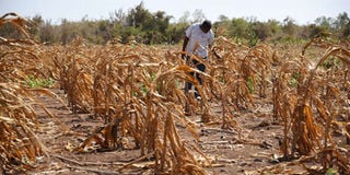
Kenya currently lacks readily available comprehensive data that can be used to guide farmers on the crops best suited to grow in the different regions. FILE PHOTO | NMG
Strathmore University’s Sh554 million (€4.9 million) project is set to start furnishing local insurers with climatic data in a bid to help firms provide tailored policies to thousands of small-holder farmers.
Head of Data Science and Analytics at the institution’s iLabAfrica, John Olukuru, said the four-year European Union-funded project saw the university install weather stations to collect data on rainfall patterns, soils conditions and other related data.
Kenya currently lacks readily available comprehensive data that can be used to guide farmers on the crops best suited to grow in the different regions, which can lead to huge crop losses due to erratic rains and lack of know-how by farmers.
“The data will help insurers inform the farmers on the best crop varieties based on soils and the rainfall patterns. Insurance firms will then use the tailor their policies based on these factors to reduce possibilities of huge crop losses,” Dr Olukuru said last Friday.
He added that they have already installed 20,000 weather stations across the country. It is targeting setting up a weather station per every 30 square kilometres to collect data that will be stored at Strathmore University.
Food production
The data will be collected through observation and satellite technology in efforts to boost food production as farmers reel from huge losses blamed on several factors including erratic rains, lack of inputs and quality data.
The project that started last year comes as Kenyan insurers continue to shy away from providing policies for farmers due to the perceived high risk involved.
The World Bank last year said that the country should deploy drone aerial surveillance, satellite GIS and weather data analytics to help small-scale farmers identify the best crops and soils to boost production.
Unlock a world of exclusive content today!Unlock a world of exclusive content today!